Tropical Cyclones
Condition for Emergence:
- A large and continuous supply of warm and moist air can release enormous latent heat.
- Strong Coriolis force that can prevent the filling of low pressure at the centre (absence of Coriolis force near the equator prohibits the formation of tropical cyclones between 0°-5° latitude).
- Unstable conditions through the troposphere create local disturbances around which a cyclone develops.
- Absence of strong vertical wind wedge, which disturbs the vertical transport of latent heat.
Most of the cyclones originate between 10°-15° north latitudes during the monsoon season.
Formation of Tropical Cyclone:
See Tropical Cyclones from our Geography book for a detailed understanding of this topic.
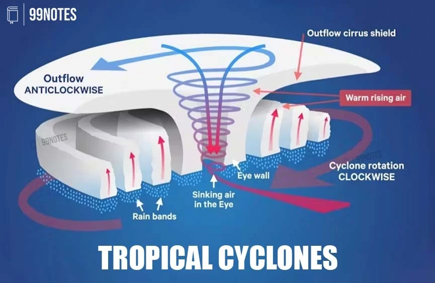
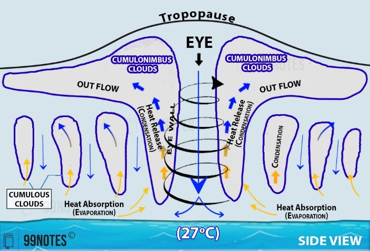
A Tropical cyclone is like a heat engine that is energised by the release of latent heat of condensation. Moisture that the wind gathers after moving over the oceans and seas.
These are typically characterised by large pressure gradients.
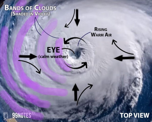
- Eye of the storm: mostly a warm and low-pressure, cloudless core.
- Generally, isobars are closely placed – showing high-pressure gradients. Normally, it varies between 14-17mb/100 km, but sometimes it can be as high as 60mb/100km.
- Expansion of the wind belt is about 10-150 km from the centre.
Spatio-temporal Distribution of Tropical Cyclone in India:
The Indian coastline is around 7,500 km; there are 96 coastal districts (which touch the coast or are close to it), with 262 million people exposed to cyclones and tsunamis.
Owing to its Peninsular shape, the tropical cyclones in India originate in these two important locations:
- In the case of the Bay of Bengal:
- Cyclones mostly develop during the months of October and November – between 16°-2° N latitudes and to the west of 92°E (near A&N islands).
- By July the place of origin of these storms shifts to around 18° N latitude and west of 90°E (near the Sunderban Delta).
- In the case of the Arabian Sea: Cyclones develop during the summer monsoon (June to August). Many cyclones recurve to hit the Western coast of India.
Between 1891 and 2020, out of the 313 cyclones crossing India’s eastern and western coasts, 130 were classified as severe cyclonic storms. The West Coast experienced 31 cyclones, while 282 cyclones crossed the East Coast. The Odisha coast witnessed 97 cyclones, followed by Andhra Pradesh (79), Tamil Nadu (58), West Bengal (48), Gujarat (22), Maharashtra/Goa (7), and Kerala (2).
Consequences of Tropical Cyclones
Since energy comes from the latent heat released by the warm moist air, with the increase in distance from the sea, the force of the cyclone decreases:
- High Wind Speed: The coastal areas are often struck by severe cyclonic storms with an average velocity of 180 km/h. Uprooting Trees and houses – killing people.
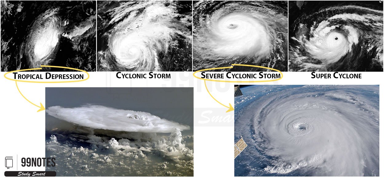
| Classification | Wind Speed | ||
| Low-pressure Area | Low-pressure area | < 17knots (31kmph) | |
| Depression | Depression | 17-27 knots (31 to 49kmph) | |
| Deep Depression | 28 to 33 knots (50 to 61kmph) | ||
| Cyclonic Storm | Cyclonic Storm | 34 to 47 knots (62 to 88kmph) | |
| Severe Cyclonic Storm | 48 to 63knots (89 to 118kmph) | ||
| Very Severe Cyclonic Storm | 64 to 119 knots (119 to 221kmph) | ||
| Super Cyclonic Storm | > 119 knots (above 221kmph) | ||
Note: This classification is based on 3 3-minute sustained wind speed.
- Storm Surge: Often high wind speed results in an abnormal rise in the sea level known as Storm Surge: generated due to the interaction of air, sea and land.
- Heavy inundation of coastal areas.
- Increased Ground salinity – adverse impact on agriculture & freshwater marine life.
- Heavy downpours: Flooding even the inland areas; Unseasonal rains can also be harmful to crops.
- Rough Seas: Many fishermen go into the deep sea. Such voyages last for as much as 10 days. Sometimes Cyclones don’t give enough time; Recently, Cyclone Tauktae an extremely severe cyclonic storm took more than 75 people’s lives in Maharashtra drowning a ship.
| Global Climate Risk Index Report 2021 |
| India ranks the 7th worst-hit country globally in 2019 due to the frequent occurrence of extreme weather-related events. Moreover, the report showed that India lost around 2,267 human lives, while damages stood at $69 billion in Purchasing Power Parity (PPP) terms in 2019. In the same year, India ranked 1st concerning human deaths and economic losses due to extreme weather-related events. |
Impact of Climate Change:
Increasing sea surface temperatures in the northern Indian Ocean and the geo-climatic conditions in India have led to a rise in the frequency of devastating cyclones in the coastal States accounting for 7% of the global tropical cyclones, according to India Meteorological Department (IMD), 2013 data.
The trend of Increasing Frequency:
- The World Bank and the United Nations (2010) estimate that around 20 Crore urban residents will be exposed to storms and earthquakes by 2050 in India.
- Every year, around five to six tropical cyclones are formed in the Bay of Bengal and the Arabian Sea; of these, two to three turn severe.
Changes in Climate: In 2014, a paper in the American Meteorological Society’s Journal of Climate warned “the western tropical Indian Ocean has been warming for more than a century, at a rate faster than any other region of the tropical oceans.”
Features of increased Cyclonic events:
- Pre-Monsoon events: Tauktae is the fourth consecutive pre-monsoon extreme weather event in the Arabian Sea, indicating new disaster management and planning challenges for the country’s western shores.
- Increased Frequency: Phalin (2013), Hudhu(2014), Vardha(2016), Mora(2017), Okhi(2018), Amphan(2020), Vayu(2019), Nisarga(2020), and Tautke(2021) are the extremely severe cyclonic storms in the recent times.
- Re-curving of Cyclones: Tropical cyclones would become more intense. They after passing over the peninsular region often re-intensify in the Arabian sea and re-curve back to the west coast.
- Devastating cyclones in the Arabian Sea: Traditionally, the Bay of Bengal has been more prone to cyclonic activity compared to the Arabian Sea due to warmer oceans. In the Arabian Sea most of which would dissipate over the sea.
Since the super cyclones in Gujarat in 1998 and Odisha in 1999 resulted in a significant reduction in the loss of lives, India has improved its systems.
Impact of Cyclone
Cyclones constituted the second most frequent phenomena that occurred in 15% of India’s total natural disasters over 1999-2020.
- Economic Damage: Cyclones are the second most expensive in terms of the costs incurred in damage, accounting for 29% of the total disaster-related damages after floods (62%).
- Cost to life: During the same period, 12,388 people were killed, and the damage was estimated at $32,615 million. 3rd most lethal disaster in India after earthquakes (42%) and floods (33%).
- To Agriculture: Due to heavy winds, rains and increased salinity after the storm surge, crops often get destroyed.
- Cost of Evacuation: Evacuating populations during cyclones in India incur significant costs, including transportation, shelter, food, and medical aid. States often evacuate hundreds of thousands of residents; for instance, during Cyclone Dana, Odisha relocated 50,000 people to relief shelters.
- Depleting green cover in urban areas: The large-scale uprooting of trees in the urban areas affected already depleting green cover.
- Increase in the fiscal burden of governments through increased spending to implement effective cyclone preparation measures. Direct government expenditure on natural calamities increased 13 times. The Asian Development Bank’s report in 2014 estimated that India would suffer a loss of around 1.8% of GDP annually by 2050 from climate-related events.
- Loss to GDP & Revenue: India lost around 2% of GDP and 15% of total revenue over 1999-2020.
Between 1999 and 2020, cyclones inflicted substantial damage to public and private properties, amounting to an increase in losses from $2,990 million to $14,920 million in the absence of long-term mitigation measures.
Measures taken by the Government
Fatalities due to cyclones declined from 10,378 in 1999 to 110 in 2020; the significant drop was on account of improved early warning systems, cyclone forecasting, and better disaster management activities such as timely evacuation, rehabilitation and relief distributions.
Mitigation of Risks and Preparedness:
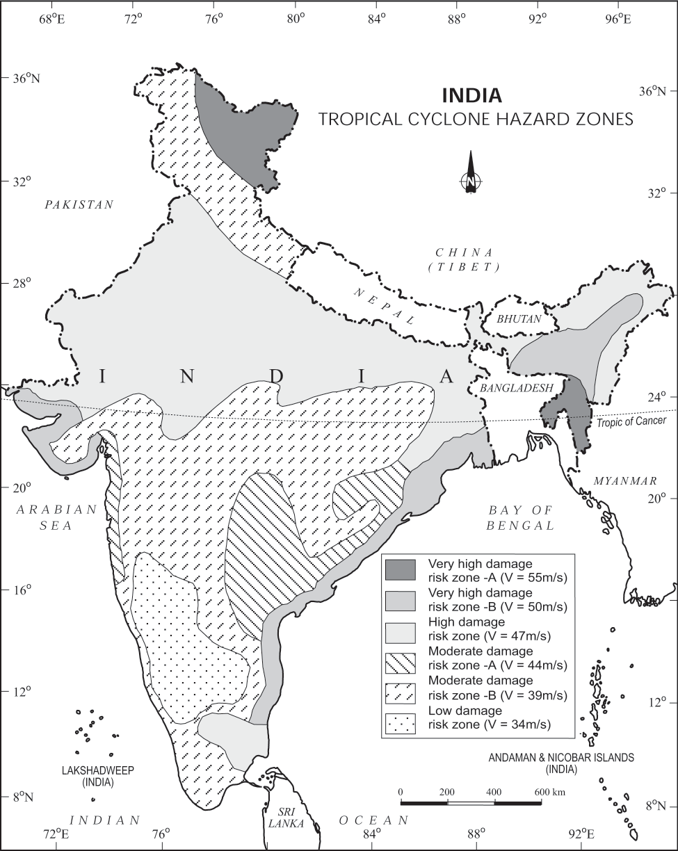
- Mapping of Spatio-temporal Distribution of Tropical Cyclone: has been prepared by the National Disaster Management Authority (NDMA).
- Tracking of Cyclonic Disturbance: With advanced weather satellite SCATSAT and GSAT-INSAT systems, the Indian Meteorological Department (IMD) is able to predict cyclones more efficiently.
- IMD’s Colour Coding of Cyclones: It is a weather warning that is issued by the IMD to aware people ahead of natural hazards. The four colours used by IMD are Green, Yellow, Orange, and Red.
- Preparedness: Comprehensive disaster management projects like the National Cyclone Risk Mitigation Project (NCRMP) have a total outlay of ₹235 crore.
Legislative & Policy Measures:
- Disaster Management Act: To bring clarity to the roles of various organizations in disaster response.
- State-wise Disaster Response and Preparedness Plans.
- Coastal Regulation Zones (CRZ) – The CRZ Notification 2018 and 2019 bring new reforms with respect to the sustainable development of coastal areas. Read in detail about the Coastal Regulation Zones in the linked article.
Engagement with the Community
- Information dissemination: ‘Mausam IMD’ is the most reliable official government website. It has been developed by the Ministry of Earth Sciences and offers all kinds of cyclone tracking.
- National Cyclone Risk Mitigation Project: Its aim is to protect vulnerable local communities from the impact of cyclones and other hydro-meteorological calamities through structural and non-structural measures. It is being implemented by NDMA, with the financial assistance of the World Bank.
- Integrated Coastal Zone Management (ICZM) Project: It aims to bring a comprehensive plan to manage coastal areas. In August 2019, a draft of the Environmental and Social Management Framework (ESMF) for integrated coastal management was released by the Environment Ministry (MoEFCC).
| Measures in Odisha |
Odisha’s history with cyclones – Odisha is the most susceptible to cyclones out of all states in India.
After 1999, the Government of Odisha took up various cyclone mitigation measures which included:
All these activities have helped to minimise the toll from cyclonic storms such as Hudhud, Fani, Amphan, and Yaas. Still, Odisha’s disaster management model is inadequate to minimise the economic losses that result from cyclones. |
Measures for Risk Reduction for Cyclones
- Hazard Mapping–predict the vulnerable areas using patterns of old cyclones, geographies of coast and wind patterns.
- Construction of Safe zones – These are structures in-land in safer locations that can accommodate the vulnerable population evacuated at the time of cyclone. These can also be artificial hills.
- Flood Management – The drainage systems should be well-designed; the government and local community are required for this.
- Shelter belts – To increase the water infiltration capacity, shelter-belt plantations to break wind speeds, mangrove shelterbelt plantations to resist storm surges etc.
- Saline Embankment and Levees – Along the coast to protect habitation, agricultural crops, and other important installations.
- Land use planning – settlements can be avoided in the most vulnerable areas such as floodplains.
- Building cyclone-resilient infrastructure – such as constructing storm surge-resilient embankments, and canals and improving river connectivity to prevent waterlogging in low-lying areas is important. Installing disaster-resilient power infrastructure in the coastal districts, providing concrete houses to poor and vulnerable households.
- Retrofitting Non-Engineered Structures – to ensure resilience. Ex: Construction of a steep-slope roof to avoid the risk of being blown away, anchoring strong posts with solid footings on the ground, Plantations of trees at a safe distance from the house to help break the wind forces, Repair of the shelters before time.
- Awareness of the public – The participation of the community increases with the number of public awareness initiatives. Governments at all levels should initiate programs bringing awareness about natural calamities and making provisions for higher local participation in the mitigation process.
- Improve the cyclone warning system and revamp disaster preparedness measures.
- Healthy coordination between the Centre and the States concerned is essential to collectively design disaster mitigation measures. It is only such a collective mitigation effort by the Centre and States that can help reduce the fiscal burden of States and also be effective in minimising disaster deaths.
Conclusion: With the help of advanced systems in place, more than 2 lakh people were evacuated in the coastal states to temporary relief shelters this year during cyclone Tauktae. Nevertheless, the states along the western coast have much to learn from the experiences of their counterparts on the east — both in terms of successes and failures. As a first step, they need to invest in more cyclone shelters. Over the long term, conversations must be initiated on ways to factor in climate-related vagaries while planning construction and developmental activities close to the coast.
| 1st ‘National Conference on Coastal Disaster Risk Reduction and Resilience (CDRR&R) – 2020’ |
| Organised by: National Institute of Disaster Management (NIDM), in New Delhi.
The conference focused on enhancing human capacity in terms of a better understanding of coastal disaster risks and effective collaborative actions, by implementing the Prime Minister’s 10-point agenda and Sendai Framework for Disaster Risk Reduction. About NIDM: The statutory body under MHA was constituted under the DM Act 2005. It has been entrusted with the nodal national responsibility for human resource development, capacity building, training, research, documentation and policy advocacy in the field of disaster management. |



![National Human Rights Commission (Nhrc) [Upsc Notes] | Updated December 13, 2025 National Human Rights Commission (Nhrc) [Upsc Notes]](https://www.99notes.in/wp-content/uploads/2024/01/national-human-rights-commision-featured-667168d64d9c6-768x500.webp)